From The Arctic To Denali National Park

We hung out in Kotzebue (see previous post) in the arctic for the next day, hoping the smoke would clear so we could fly out to the Brooks Range. No luck. Working in the the hangar shed of our bush pilot was his son, doing whatever needed done: answering the phone, picking up customers in the battered Suburban, and more importantly, monitoring the radio network, the lifeline that connects bush pilots to small villages and outposts all over the western Alaskan arctic. Half Inupiat, half white, he’d been flying since he was twelve. Now fifteen, he was totally comfortable setting a little Piper Cub down on and taking off from a river gravel bar anywhere in the bush. By his estimation, he already had over a thousand hours of air time and hundreds of landings and take-offs under his belt. I asked him about a story I’d read about a Piper Cub in the Alaskan arctic that had its fabric flying surfaces shredded by a grizzly while the bush pilot was hunting. The story was that he’d repaired the plane with duct tape and flew out successfully. “Yeah, that story is true….that was my uncle.” He was waiting to turn sixteen so that he could (formally) get his pilot’s license. Sixteen is the age when you’re legally supposed to begin flying. Right. I told this young man (whose name will remain anonymous for obvious reasons), how lucky he was. “You’re going to be a bush pilot just like your dad, eh?” “Yeah…that’s what I’m gonna do”. “Ever think of doing anything else?” “Nope…” How’s school here in Kotzbue?” “Great.” “What’s your favorite class?” “P.E.” “What sports do you do?” “Cross-fit.” “Cross-fit?” “Cross-fit.” He was one of the most focused and relaxed kids I ‘d met in a while. I thought of all the teenagers back in California who where under great pressure and stressed-out by having to choose from about a million options what they were going to do with their lives. They need to be “successful”, whatever that is. This kid knew what he wanted. He was set. That was something I had not seen outside of places like Madagascar and Papua New Guinea – kids totally content with where their lives were going and unconcerned by the limited number of choices available to them. The kid was very low-key and soft spoken, but with a strong air of confidence in the way we’d observed other Inupiat were. If you offered him an all expense paid scholarship to Stanford, he wouldn’t take it. I say that because another woman in Kotzebue told us of her daughter who did have a full tuition/room and board scholarship to Stanford. I wondered what was in store for her.

Piper Cub Tundra Tires1

A Piper Cub in Kotzebue, above the Arctic Circle- ride of choice for many arctic bush pilots. Note the “tundra tires” – big and soft…”I can land on anything with those….” Many of these Pipers were bought still boxed as World War Two surplus. Seventy years on, they’re still flying strong. 

Flying back to Anchorage, we picked up the truck again and headed up the Parks highway towards Denali National Park. On the way we stayed at the Alaskan Host B&B in the hamlet of Willow. The Host is best be described as a place were sinful vegans might be sent as punishment in the afterlife. This place had a stuffed one of everything on the wall: a grizzly advanced from the corner of the living room. Dall sheep, moose, lynx, black bear, beaver, otter, ducks and jumbo sized salmon, pike and graying hung from every possible wall space. Jim and Kathy, the owners, were about as nice a folks as you’ll ever met. Jim was born in Morgan Hill, just south of what is now Silicon Valley. After World War II, his father, a machinist and restless veteran, read about homesteading in Alaska. One hundred and sixty acres. Free. All you had to do is clear part of the land and grow something “commercial”. Anything. He was sold. He bundled up Jim and the rest of their family, settling in the valley of the Susitna river about a hundred miles north of Anchorage. In the fifties, this was still pure wilderness (and it still mostly is…). Jim told us stories. “What about grizzlies?” “They won’t bother you unless you leave garbage around.” “But, one time a big moose came right up to the house…” Their dogs began harassing it. Before they could do anything, all thousand pounds of agitated ungulate crashed through their front-room window. Jim’s dad shot it before it could further advance towards his mom’s porcelain tea set.

In the morning, were were served, among other delicious things, moose sausage. It was fantastic. There is rarely an extended conversation among rural Alaskan locals that doesn’t include something about getting their moose. For Alaskan residents, it’s not too difficult to get a permit to take one moose a year, for many an economic necesssity. That moose will put hundreds of pounds of mild, lean, flavorful meat in your freezer – enough to feed a family of four for a year. If your neighbors didn’t get theirs, you shared yours. Moose steaks, moose ribs, sausage, burgers. You name it. Lean and healthy, with a complex flavor that speaks of the animal that browsed alder and birch and willow along pristine river lowlands. No feedlots here. You can’t buy moose in the stores, which is why we were glad Jim and Kathy graciously served us some of theirs.

Alaskan Host BB1

Jane and Jim discussing the finer points of the future of the Alaskan Bush. 

Next, on to Denali National Park….

Happy travels,

Bryan and Jane

Advertisement
Posted in Uncategorized | Leave a comment

The Haines Highway and Arctic Interruptus

Flying back from Gustavus to Haines, we found the truck as we left it at the Haines “Airport” – a little building with a desk, a small bathroom and a friendly dog – ID checks and the TSA have not yet arrived in this little southeastern Alaskan village. Fluorescent pink fireweed and snow white yarrow naturally decorated the grounds. The Haines Highway picks up were the Alaska Maritime Highway ends, providing a segway to the Alaskan Highway via the hamlets of Haines Junction and over the Canadian border in the Yukon, to Beaver Creek and then Tok, back in Alaska, a distance of over three hundred miles. Driving north, a glacial melt river was the foreground with the massive Wrangell St. Alias mountains in the background. The national park of the same name, combined with the abutting Kluane National Park in Canada make up the largest national park system in the world. At over fourteen thousand feet, Mt. Wrangell, an active volcano steamed ominously in the distance. Wrangell last errupted in 2002, spewing thousands of cubic yards of ash and closing air routes in the northern hemisphere for days. Along the way, small “kettle lakes” dotted the landscape. Legacies from the Pleistocene, these subarctic jewels were created when massive blocks of ice detached from receding glaciers, became buried in sediment, then melted, leaving a cast of the landlocked berg which then filled with water. Stately Trumpeter Swans breed almost exclusively in these lakes, gliding gracefully over their water, signets in tow, feeding on the abundant aquatic vegetation that twenty plus hours of summer sunlight a day produces. Down to seventy individuals in the 1930’s, Trumpeters, the largest bird in North America are now making a comeback.

Along the way, we listened to an audio version of John McPhee’s classic “Coming Into The Country” about life in the Alaskan/Yukon interior. Satisfyingly, at over forty years old, it still rings true here.

Leaving Alaska and entering the Yukon Territory of Canada, we chatted briefly with the customs officer at the lonely border crossing. “What’s the greatest wildlife you’ve seen here?” “Well, there was that stripper that went thru a while back….” Delivered with a straight face – a classic Alaskan answer. Overnighting in the hamlet of Haines Junction, we pushed further into the Yukon and were blown away by the sheer vastness of this place. Valleys, and river drainages followed by mountain ranges and sweeping panoramas to the horizon times ten. All without a single sign of man: no roads other than the one we were on. For hundreds of miles. No towns, houses, strip malls, cell towers, ranches, livestock. Nothing but tundra and boreal forest forever and ever. You don’t pass up a gas station on this road. We stopped for lunch at Buckshot Betty’s in Beaver Creek, population 103, down eight percent from the last census. Inside was our introduction to what would be the standard small Yukon/Alaskan restaurant/general store/whatever. Furs for sale from local trappers: beaver, arctic fox, wolf, wolverine. A massive grizzly hide adorned one wall, Dall sheep headmounts (white big horn) and monster salmon another. Our waitress was from a small town in Manitoba, had only been working there for a few weeks. She was saving to study graphic design in Toronto.

Built just before, and during the Second World War, the Alaskan highway pushed a road into total wilderness. Along the way, supply depots were established, one named Tokyo. After Pearl Harbor, the name became a liability, so, in the spirit of Alaskan practicality, the last few letters were lopped off, and Tok was born. Nowadays Tok is a crossroads town on the Alaskan Highway and tends to business: fuel, hardware, a landing strip for bush pilots and helicopters. RV repair. Everyone eats at Fast Eddie’s. From Tok, we pushed on to Anchorage via the Tok Cutoff, skirting the mighty Copper River and the Alaskan Range. In 2012, more than 46,000 Sockeye (red) salmon were counted entering the river in a single day. The next day, we boarded a hybrid cargo/passenger 737 jet and flew to the Kotzebue, thirty miles above the arctic circle.

The Curious Village Of Kotzebue

Located on a slender peninsula jutting into the Chukchi Sea, Kotzebue (pronounced “kot-sa-bue”) is a supply point for dozens of remote arctic communities and modern industrial enterprises in northwestern Alaska. It is also home to a sizable population of the Inupiat people native to the area. After landing, we discovered that the little departures/takeoff building was flooded by Shell Oil employees, just landed, and awaiting the massive drilling platform currently being towed into the Chukchi Sea from Seattle, more than a thousand miles south. The drilling permits were not yet approved, but apparently that was not stopping Shell. Our plan was to meet our bush pilot , who would fly us up to the western end of the Brooks Range of mountains in the high arctic. More than a hundred thousand Barren Ground Caribou would be assembling for their annual calving and migration. Our only plan was to camp there and watch what happened: caribou, wolves and grizzly bears doing what they have done for millennia. With the weather holding, our bush pilot would return in four day’s time to collect us. But a strange and new phenomenia torpedoed that plan: massive bush fires….more than three hundred of them. Visability in Kotzebue was reduced to a few hundred yards. Everything that could fly was on the ground, including our bush pilot, a hundred miles away, landed and stranded by the visibility on the gravel bar of a river: bush pilots fly by visual only, to do otherwise invites the grim reaper. An easterly wind had foiled our plan, carrying the smoke for hundreds of miles from the Alaskan interior to set up a Beijing-like haze into tiny Kotzebue. We asked around among the Inupiat locals. “Is this normal, to have smoke like this?” “I am eighty years old, and I have never seen this. I wonder what is happening. I am worried…” This was actually the least of their problems. The permafrost, the soil permanently frozen a few feet below the surface, was melting, eroding the peninsula – their home – from underneath their feet. The summer pack ice, never more than a dozen miles or so offshore, and funneling whales and seals close to shore where they could be hunted, was now a hundred miles out into the Chukchi Sea. You cannot tow a forty ton whale back that far. Their livelihood for thousands of years was becoming impossible. During the winter, more than once, it rained. Rained. In the arctic. Then it froze, creating an icy armor over the lichen moss that the caribou and Dall sheep normally pawed through the soft snow to get at – indispensable calories when it is forty degrees below zero. They died in their thousands, and with their deaths, food for the locals was denied. There were no non-believers in global warming in Kotzebue. There was talk about Shell, and the new future…..

Trumpeter swan2

Stately Trumpeter Swans with their signet young in a “kettle” lake along the Haines Highway.
Kotzebue Smoke1

Kotzebue: 30 Miles Above the Arctic Circle – fire smoke reduced visability to 100 yards. No bush planes flying. Arctic Dreams postponed……
Next, Denali and the Delali Highway

Posted in Uncategorized | Leave a comment

On To Glacier Bay

Our magnificent three day journey up the inside passsage came to an end at the village of Haines Alaska. Located at the end of a fijord (Alaskans call them “arms”) off the Lynn Passage that leads a hundred miles south to Juneau, Haines is one of only two points where you can access the interior by road in the vast Southeast of Alaska. And that access is via the absolutely spectacular Haines Highway. But I get ahead of myself. Before that drive, we flew out on a little Cessna bush-jumper through a pass in the the ten to fifteen thousand foot coastal range – the highest in the world – to the Alaskan hamlet of Gustavus (pronounced “gu-stay-vus”). From there we made our way to the Glacier Bay Inn, closer to our intended goal of the same name and located within the National Park on Bartlett Bay. If you to to Glacier Bay, and I would urge that you do, stay at this place. You can sit on the deck sipping a drink and watch humpbacks feeding in the bay below. Orcas are often sighted as well from that cozy perch.

Glacier bay is a geologic wonder that leaves anyone with even with a minimal sense wonder in a state of awe. Massive glaciers creep, crack and rumble to the sea where gravity extrudes them like a giant, flattened, crumbly tube of toothpaste into the fijords. Most people have seen photos or video of Glacier Bay’s famous tidewater glaciers, but one of the things often missed is the scale. A fifteen story, thousand foot long cruise ship parked in front of the most famous of them, the Marjorie Glacier, looks almost toy-like in comparison. But the glaciers are only a part, albeit an impressive one, of Glacier Bay National Park. Small green patches on the great mountains that plunge into the fijords, hold snow white mountain goats grazing improbably in this vertical world. One stands just a few hundred yards from our boat, the Baranov, which we had boarded that morning for a water-level view. Bald eagles soar overhead. Here, they are so common the locals don’t give them another glance. The waters teem with sea otters, massive Steller’s sea lions, Dall and harbor porpoise, orcas, salmon and monstrous halibut (see below). Brown bears patrol the coves . For an extra $25, the Baranov will drop and pick-up you and your kayak deep within the park’s network of fijords, leaving you free to explore this incredible wilderness on your own, at your own pace. A few passengers took advantage of this opportunity. Others, out for days or weeks, were picked up. My mind rewound some 25 years earlier when I’d done a similar kayak trip in the remote fijordland of the Prince William Sound, not too far away. No paddling experience I know of can compare to the spectacle of southeast Alaska. These massive glaciers become living, breathing things when you spend some time with them. Do that and you’ll know what inspired the Vikings to seek the Norse gods of yore. Truly, here is Thor striking his mighty anvil. You need only open your senses and breathe it in.

The following morning, we set out through the Icy Strait through a small pass in the massive, glacier-clad coast range, leading us out of Glacier Bay and into the Cross Inlet and the Gulf of Alaska. A rare clear morning treated us to a view of Mt. Fairweather, towering more than fifteen thousand feet above the Strait, yet inland from the sea only about thirty miles, its flanks coated with massive glaciers. It was just Jane, myself and Mike, who captained a typical 30 foot aluminum sportfishing boat in these parts. The boat had a small pilothouse in which about four people could get out of the weather and an afterdeck where the action happened. Our quest that day were to include any of the five species of salmon that could be caught, but primarily Kings (Chinook) – the largest, tastiest, and most sought after – followed by Silvers (Cojo ) and possibly Pinks (Humpback). But our primary objective was Pacific Halibut. In our hometown of Santa Cruz, a (California) halibut to brag about might be 40 lbs. If you fly to Alaska, look up upon your arrival at the Anchorage Airport and you’ll see a nine and a half foot, 440 lb halibut, forever swimming through the lobby in its huge plexiglass display case. And that is not even close to being the biggest ever caught. Deepwater long liners have brought up individuals exceeding 800 lbs. We were not after that kind of sea monster, rather, something in the 30 to 80 lb range that would put us, after vacum packing, flash freezing, and, compliments of FedEx Overnight, in fish tacos for the foreseeable future.

So what kind of gear does one use to catch Alaskan Pacific Halibut? Start with a pole as thick as a carpenter’s thumb, furnish that with a big reel and 80 lb test braided line, then end it with a hook about the size of the top end of a coat hanger. Next, find a place swept with a good current and bait your coat hanger. The best bait is something that will deliver a powerful scent trail down-current: herring and salmon belly are favorites. Drop it down up to three hundred feet, accelerated by about two pounds of lead weight, reel it up about four feet from the bottom and wait. Fish taco candidates will soon start working their way up current, homing in on the yummy scent trail you are broadcasting. Motivated players can come from as far as a mile away. Inevitably, you’ll register a strong tap-tap-tap on your rod, or a massive slam from a big girl (all halibut above about 100 lbs are female). You swing back on your rod and its previous broomstick-like demeanor bends into an arc. You winch in a few feet, then the halibut strips off fifty in a run. This is repeated, with the line you winch up increasing and the runs decreasing, if you are lucky. After fifteen minutes…or four hours, your captain or deck hand can gaff your ‘butt and you’re in the tacos. “Barn doors” are usually shot, then harpooned before bringing them over the transom. A 300 lb halibut thrashing on the deck can break a leg, or worse. The limit for non-Alaskan residents on halibut is one per person. Jane’s ran about 25 lbs, mine a bit over 30- perfect eating size. Earlier in the day, Captain Mike put us on the Kings, we each landing our one alotted fish, then I winched up a monster ling cod. At over four feet, it was much too large to legally keep. We released it without bringing it over the side. What is a ling cod? Think of a huge swimming head full of sharp teeth, but yielding white, sweet, flaky fillets, some colored a shocking shade of blue until cooked. Mike calls them “giant lizard fish”. A dozen rockfish, incidental but tasty bycatch while trolling, also came in, Finally, we fished for Silver salmon, the limit being five each. A steady series of strikes on the downrigger trolling device yielded three, and a bonus Pink salmon. The weather closed in in the early afternoon and we headed for the barn short of our Silvers limit. You don’t mess with weather in the Gulf of Alaska.

Glacier Giant Halibut2 

At the dock, the boat behind us had on board a six and a half foot, 240 lb halibut. They had used a two foot, four pound whole pollack for bait. The four guys fishing took turns on it for over an hour. That girl, left in the sea, would produce millions of eggs a year, a down payment on future halibut generations. Don’t know why they kept it. I like fish tacos as much as the next guy, but what are you going to do with a 150 lb of fillets from that one fish, no to mention the seven others (Alaskan residents can keep two) of lesser size kept between the four of them? Guess its an opportunity to make new friends, and then make them into new enemies when you inevitably demand they come over yet again for fish tacos. Kinda like the seafood version of the home gardener that plants an excessive number of zucchini- you see them coming up to the front door with more monster zucchini torpedoes in a basket and pretend not to be home.

The next night, we invited Mike to dinner at the Lodge where were staying. He had his 1,000 ton license, meaning he probably could have captained the Marine Highway ferry that bought us here. He had skippered ships far and wide, had been all over the place, and was preparing for the “unlimited” test, permitting him to captain gigantic ocean container vessels. But his passion was skippering sportfishing boats. And he, like many others we’d met, was here because he’d fallen in love with Alaska. We encouraged him to come down and stay with us in Santa Cruz for a bit during the off season: “don’t say that unless you mean it ’cause I know Santa Cruz and I love the damned place.” We did and we hope he will.

Next post: up the spectacular Haines Highway and into the Yukon..

GlacierBay-Mtn Goat2

A Mountain Goat Grazes On The Sheer Mountain Cliffs of Glacier Bay

Glacier Bay Marjorie Glacier Cruise Ship1

A Cruise Ship Is Dwarfed By the Marjorie Glacier, Glacier Bay.

Happy travels,

Bryan and Jane

Posted in Uncategorized | 2 Comments

ALASKA, THE YUKON AND BRITISH COLOMBIA 2015

With this post, I bring you a new series of travels “off the beaten path”, this time north with our truck (canoe on top) from our home in Santa Cruz, CA through northern California, Oregon and Washington, fifteen hundred miles up the Inside Passage of British Colombia and Alaska via the Maritime Highway ferry, then on to the Alaskan arctic, the interior of Alaska, the Yukon and British Colombia, then down through Yellowstone and home via the Green River in Idaho and Nevada.

The Alaskan Maritime Highway

At one time or another, most of us have browsed an atlas or map of North America and gazed with wonder at the incredible maze of islands, fjords inlets, straits, islands and passages that is southeast Alaska and coastal British Colombia. Stretching more than a thousand miles from the Washington state border to the roadhead at Haines in Alaska and beyond lies an immense wilderness of temperate rainforest, great mountain ranges, glassy calm inlets and rumbling glaciers nearly a mile thick. Thousands of islands, some larger than Rhode Island populate the entire passage, with tens of thousands of bays, inlets and coves creating something like an enormous maritime maze. What you see on any good map of the area suggests the arterial system of some complex animal more than actual geography. Virtually no roads connect the small towns and villages in this place, they being only accessible by sea or air. Because of this, places like Ketchikan, Wrangel, Petersberg and dozens of other villages, not to mention the capital of Alaska, Juneau, are dependent on the Alaska Maritime Highway which connects them to the outside world.

Along with big commercial trucks, RV’s, backpackers and Alaskan locals, we boarded the good ship Colombia at Bellingham Washington, the southern terminus of the Maritime Highway. After storing our truck in the bowels of the ferry, we settled in for the three day fifteen hundred mile journey up the Inside Passage. Our home on-board was a “stateroom” – read two bunks and a little bathroom. But most of 0ur time was spent on-deck, watching the amazing sequence of wildlife and spectacular scenery pass by. Humpback whales, busy sifting herring, capelin, sandlance and krill from the nutrient-ritch waters would blow as we passed, their massive bulk rolling and diving for another round of bio-hoovering in the jade green waters. Bald eagles would sit on stately perches, their heads rotating in unison with our passage. Small fishing boats would pass, on their way to the next salmon run. The captain would at times navigate the Colombia though straits between islands so narrow you could easily toss a rock out either side and hit the shore – that is some kind of navigating, particularly against eight knot currents wielding a thousand ton vessel.

On board, we had time to chat with fellow voyagers. Kayla, who called Jackson Hole Wyoming home, was off to spend her third summer backpacking through Alaska. In her 50’s, tall, weathered and lean, Kayla sat with Jane and I watching pelagic seabirds as the Colombia pushed on through the Inside Passage. As time passed, she described the more than half dozen close encounters she’d had over the years with grizzly bears in both Alaska and Wyoming. There was fear, she said, but mostly awe. Awe of their intelligence most of all. Fred was in his 80’s and on his way to re-visit the Cold War B-29 bomber base north of Fairbanks where he served in the early 50’s. If nuclear armageddon started, he would have been the first to respond. Several modern military families were on-board as well, en route to new posts throughout Alaska. The father of one crewed on an ice breaker in the arctic. His wife grew up in Nome. Her father was an Alaskan State Trooper responsible for policing the remote arctic villages along the Bering and Chukchi Seas. She described one fine fall morning when a polar bear decided to take a stroll down Main Street, disappearing later that day out onto the fast forming pack ice.

For me half the fun and adventure of traveling to remote places is just this – meeting interesting people, with time to hang out and talk. The further afield you travel, the more interesting they become.

Making our way north, the Colombia stopped in succession of small towns and villages: Ketchican, then Wrangell, Petersberg and finally the capital city of Juneau. In Ketchican, a bumper sticker on an ancient, rusted pickup read “Vegetarian is an ancient indian word for lousy hunter”. It was placed just below the NRA sticker. Sunday in Wrangell seemed deserted until we walked passed the town bar. Everyone in the town seemed to be in there. A placard on the door read “Hippies: use back door”…

Next, Glacier Bay, fishing for giant halibut and exploring the temperate rainforest and tidewater glaciers.

Ranier4

Above, the lush alpine meadows below Mt. Ranier in Washington, a stop on our way up to the Maritime Highway.

The Good Ship Colombia, Queen Of the Maritime Highway

AKFerry-Ketchikan3

Jane and Our Truck in Colombia’s Vehicle Hold.

AKFerryA1

Traversing the Inside Passage

 AKFerry4

Posted in Uncategorized | 1 Comment

ON TO THE ISLAND OF TANNA

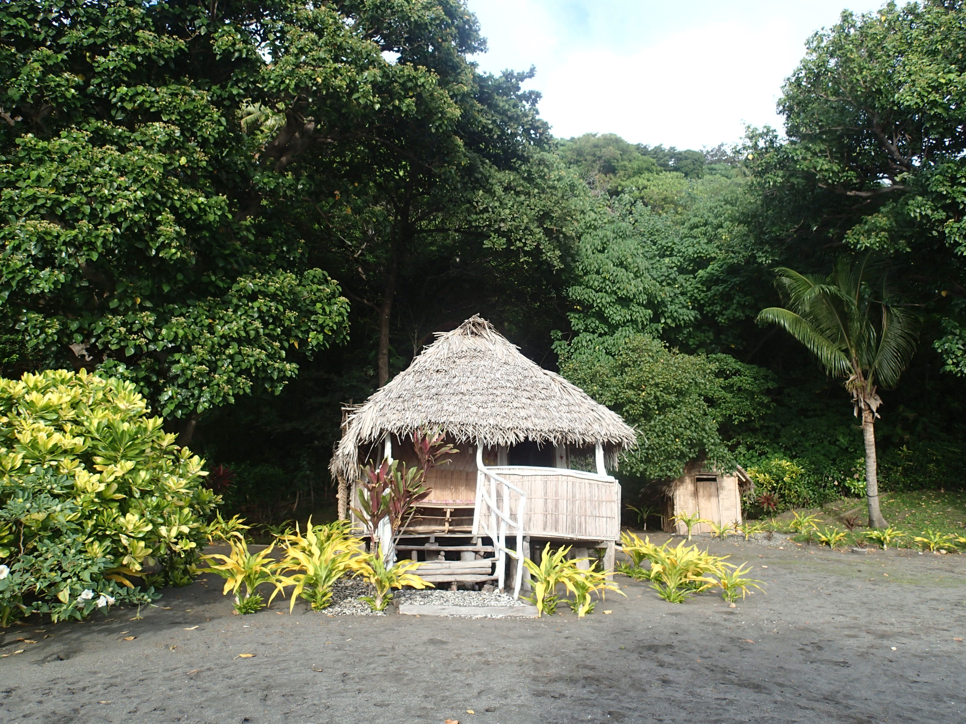
We’ve now moved to the southernmost major island in the Vanuatu chain – the beautiful island of Tanna. Tanna is still a very traditional place, with most people still living a self sustaining lifestyle – growing their own food, making their homes from traditional materials (see pics), and living a clan based lifestyle. We stayed in simple bungalows made mostly of traditional and local materials (“Friendly Bungalows”), and run by local villages on a beautiful beach just east of the Yasur volcano (see below). Tanna is what one imagines when one thinks of a tropical paradise. Though their life is simple by Western standards, the Tannese we met are a contented people. Food is easy to grow in the rich volcanic soil, and there’s plenty of time most days to enjoy kava (see future post) with family and clan members. Homes are built along traditional Melanesian lines – walls and mat floors of split and beautifully woven cane, with roofs of pandanus (a palm like tree) thatch. The Tannese are always quick to smile and greet and you can safely walk anywhere through beautiful forests and gardens, with spectacular vistas of black sand beaches and the azure South Pacific (pictures below).

We came to enjoying the beauty of the place and learn more about the culture: Jane took an amazing traditional foods cooking class – hot stone steaming with no metal pots or cooking instruments, with the fire being lit by a traditional wood friction method in just a few minutes. One of our other objectives was to visit the Yasur volcano, which has been erupting continuously for hundreds, and possibly thousands of years. In 1776 and on his second Voyage Of Discovery, Captain Cook sighted the glowing caldera of Yasur far out at sea and thus the was one of the first Europeans to visit Tanna where they anchored, watered and replenished at what is now known as Resolution Bay (named after his ship).

The Yasur Volcano

As mentioned in previous posts, our travels in the South Pacific have taken us along parts of the “ring of fire” surrounding the Pacific. From the main island of New Guinea and onto to New Britan in the Bismarck Archipelago, rarely were out of sight of active volcanoes, they being created by the subduction of the Australian Plate under the Pacific. A bit of background: Volcanoes come in two basic types: shield and strata. Shield volcanoes are basically mountainsides from which fissures typicall pour forth liquid lava like the famous Kilauea volcano on the Big Island of Hawai’i. Strata are the classic mountains with bowl shaped caldera flinging out molten rock chunks which, building up over millennia, creating their cone-like shape. Yasur is a caldera of the “Strombolian” type, meaning it acts like what the Romans called “the lighthouse of the Mediterranean”, the Stromboli volcano, which has been in a continuous state of low level eruption for millennia (Yasur probably has been too). At just over a thousand feet tall, there is arguably no active strata volcano in the world which you can approach so closely and easily as Yasur. Dominating the landscape, it continuously spews forth a cloud of steam and sulphur gasses, hissing, even roaring at times, and making the earth tremble. But it is at night that Yasur becomes the living, breathing embodiment of “awesome” in its truest sense. An hour’s 4WD drive with Donald (our Tannese guide) across the volcanic cinder plain and another twenty minutes walk up the cone to the caldera edge at dusk delivered us to what I can confidently say is the most awesome natural spectacle I have ever experienced. As dusk ended and night began, we stood on the lip of the caldera (no guard rails or warning signs – you need a guide) just a few hundred yards from Yasur’s twin magma chambers, the liquid rock glowing fluorescent red. Every few minutes a smaller blast of volcanic gasses spattered glowing, semi-liquid rock onto the caldera walls, and every half an hour or so Yasur reminded us why the Tannese used their word for “the gods” in naming it. A tremendous explosion – a multiple of the most powerful thunderclap – ejected blobs of lava, some the size of a refrigerator or even bigger, hundreds of feet into the air, all this going on not miles, but just hundreds of yards from us. “Loud” does not do this experience justice. You could actually see a sonic boom-like pressure wave travel across the caldera and you felt it in your chest when it passed. At times, the breeze wafted a hint of the caldera heat and enveloped us in a sulphurous fog. Humbling. Scary at times. Yes, “awesome”….to be in awe…in the truest sense of the word. This barely begins to describe the experience. And all this is just what seismologists call “Category One” for Yasur. I asked Donald, who has lived his entire life at Yasur’s foot, what Categories Two, Three and Four are like. “Category two – where we parked the truck (a half mile away), the lava is falling there. Category Three, we must evacuate the village. Category Four, the lava falls in the forest and sets it on fire.” Every day is the 4th of July on Tanna.

The Jon Frum Movement On Tanna

One of my goals in traveling through Melanesia in areas where during the Pacific War the fighting took on a scale and ferocity arguably unequaled in human history, was to get the point of view of the locals, the indigenous peoples (and ex-pats) of Melanesia about the War, many of whom were directly involved in providing the vast amounts of manpower required (to both sides): building and supplying the hundreds of airstrips, ports, roads, bridges and military installations over the vast Central and South Pacific. Now is a critical time, for much of this history is oral and those who still remember first-hand are growing old or are already gone. As described in an earlier post (from Alotau in southeast Papua New Guinea, below), for many Melanesians – those inhabiting those archipelagoes of Fiji, Vanuatu, the Solomon Islands, New Guinea and other places – the Pacific War was tantamount to someone from our Western Society being visited by aliens from outer space. For these people, then living a near stone-age existence, airplanes, enormous metal ships that made deafening noises and explosions, bombs, food wrapped in metal, big men with yellow hair, blue eyes and pale skin that turned red in the sun – all of this was an overwhelming experience. As one can imagine, they had a thousand questions, but tantamount was: “Why are you here?” And just as the Melanesians were becoming accustomed to all this, the war ended, and the white (and black) American fighting men went away. Why? Perhaps they, the Melanesians, were not performing their work properly? Did they offend the Americans? I had questions as well. We noticed that wherever we went in Melanesia and we told a local person we were from America, their face usually lit up and a broad smile crossed their face. They wanted to shake your hand and tell us: “Amerika numbawan!” Why this love of Americans? We’d bombed and bulldozed some of their lands into a lunar landscape during the War, polluted their beaches and reefs, brought death and destruction wherever our troops went and left an appalling toxic, explosive mess behind. I’d heard of the “Cargo Cults” – quasi-religious movements that prophesized the return of the big ships and all the “cargo”, said movements having emerged semi-independently across Melanesia. The Cargo Cults are what one might consider to be a natural outcome of the extraordinary experience they went through during the Pacific War, and particularly the mysterious abandonment of so much cargo by the Americans at its end (see previous post on “Million Dollar Point”). Why would they leave all these things behind if they did not intend to return? Why did they push their cargo into the sea?

This brings me to the John Frum Movement on Tanna. I’d read of it but wanted to hear about it first-hand from those living it, those who choose to live in John Frum villages on Tanna. I approached Donald, our guide up Yasur, with my interest/request. Donald advised that, yes, there was a John Frum village not too far away at the far edge of their clan/linguistic group (more than twenty languages are spoken on Tanna). We flagged down a clan member on our way back to Yasur the next day. He said he would pass on the word of my request, than an American had come to learn of the John Frum Movement and wished to visit. Permission was granted and the next day we set out on the hour and a half walk to the village which lay at the base of the Yasur volcano. With me I brought a traditional Melanesian greeting gift – a bundle of kava root (see future post on the integral role the drinking of kava plays in the South Pacific). Jane tagged along as far as the Yasur cinder plain (John Frum practices are a male, elder thing on Tanna). As we walked thru villages, people invariably looked up and smiled, and not just because Donald their kinsman was with us. These people live a relaxed, slower paced lifestyle which we’ve largely forgotten in the West as we perpetually quest for more and more “stuff”. Meanwhile Yasur smoked, hissed and rumbled in the distance. As we approached the village, we ran into several men working in their gardens along the path. One happily went ahead and advised we were approaching. Upon reaching the village, we took a seat under a tree at the edge of the village square, a leveled area being used at that moment by dozens of children of all ages in what appeared to be a spirited and energetic game of tag. The village was completely traditional. There was no electricity and little sign at all of anything “modern” at all (part of the John Frum Movement tradition – to live “Kastom”), save one small concrete block building set on a hillside nearby. In front of that building were three flags. The national flag of Vanuatu flew on one pole, flanked by an American flag, with another American flag attached to the front of the building. A short time later, Chief Isaac greeted us along with Steven, a village elder fluent in English. We made our way to the flag decorated building on the hill, which turned out to be their temple for the John Frum Movement. Upon entering, the first thing I noticed was a huge American flag draping the ceiling of the entire room. On the wall were various items associated with the Pacific War including a canvas carrying case for a Thompson submachine gun. We all sat crosslegged on woven floormat:
Chief Isaac (through Steven): “I can understand you, but I don’t speak much English. Steven will help me. Why are you here, Bryan?”
Bryan: “My wife and I have come to Tanna to enjoy your beautiful island. Thank you for hosting us. I am also interested in history. I am interested in the Pacific War. My uncle served here with the American Marine Corps. He visited Port Vila and the American base on Santo on several occasions. He fought the Japanese. I have read the American and the Japanese accounts of the Pacific War, but I wanted to hear from the local people, the people like you that live here. I wanted to hear your story. I wanted to hear about the John Frum Movement.”

Isaac, who was quite old (I did not ask his age) contemplated me for a few moments, then motioned to one of the temple walls, on which was the bright red and yellow flag of the American Marine Corps. On a table in front of it was a bayonet and a walkie talkie.

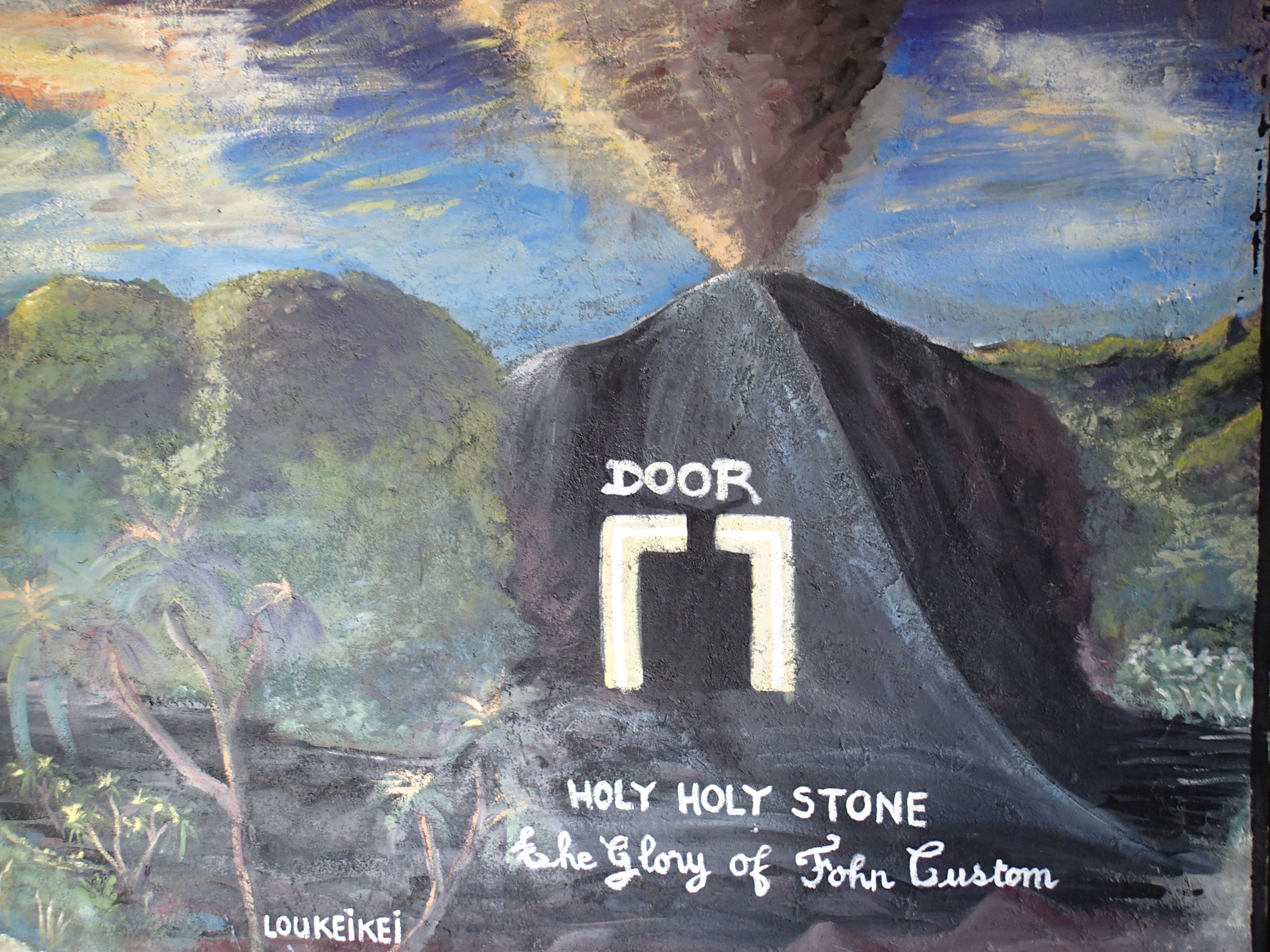
Isaac and Steven: “Before the war, we had Christian missionaries that visited Tanna. They said the old ways were no good. They said we had to stop drinking kava. They said we must become Christians. Some of us refused. The Christians did not like this and told the British and French government. They came and took some of our elders away to prison. They took them to Port Villa (the capital on the island of Efate). John Frum came to them and told of a great people in a land called America, and that Americans would come someday and free them. And the Americans would bring much cargo. The Americans came. Two thousand men from Tanna went to work for the Americans during the War. American soldiers said the Japanese were coming for us. They said that they took New Guinea and the Solomon’s. They said that we were next, but that America would stop them. Many Americans died. America saved us. Now we wait for John Frum to return. A great door will open on the side of the Yasur volcano and John Frum will come back to us through it. He will take us to the next level and the cargo will come back. We want to create a Facebook page to share the prophesy. We decide what cargo we use and don’t use. Cell phones are good. No TV. No church.”

In the foyer of the temple was a mural depicting the John From prophesy and the great door that would open on Yasur (see pictures below).

Bryan: “Isaac, how do you practice the John Frum Movement”
Isaac: “We have raised the American flag every day since 1956 (he may have actually meant 1946). Every day we raise and lower the flag. Every Friday night we dance and sing until dawn. In February, we have big events.”
Bryan: “What kind of songs do you sing?”
Isaac: “Traditional and American, like the Star Spangled song.”

Isaac then launched into a long dialogue in his local language, and in his speaking, I heard…..California…..Bill Clinton….Pendleton….Carolina….Atlanta.”

Bryan: “Chief Isaac, you have visited America?”
Isaac: “Yes”.
Bryan: “How did you come to visit America?”
Isaac: “We wrote to American Marines and they invited us. Also, Bill Clinton invited us to visit. Chiefs from several islands and our president went after our independence.”
Bryan: “What did you think of America?”
Isaac: “It is as John Frum said. I like Los Angeles and Washington D.C. and Atlanta and Camp Pendleton. At Camp Pendleton, I fired a rifle. Bryan, you look like the American soldier.”
Bryan: “Thank you, but I am much too old.”
Isaac: “Maybe one of their big men.”

Isaac and the other elders studied me a bit. I could clearly see they wanted to ask me something, but they declined when I prompted. We talked some more about John Frum. The translational vibe clearly seemed to be that maybe John Frum had sent me, that I might be some kind of an emissary of John Frum. That this was part of John Frum’s plan. This was definitely in the air (or maybe I was just imagining it), but I did not ask, fearing such a question would be inappropriate (I now regret I did not).

The kava root bundle was given to Steven by Donald (it is traditional that you have a second person to do the exchange) and I made a small cash contribution to the village, the use of which would be decided by the elders – as was “Kastom”.

As we walked back to where we were staying, I asked Donald what he thought about the John Frum movement. “I’m a Christian. They are not. That’s OK. We just try to be happy. Do good things. Take the right path in life. We all feel the same way.” Such a beautiful, fascinating, tolerant people…. “Donald, we Americans could learn much from you Tannese…” And that is what we discussed on our walk back.

Final post: Short stories, and observations: Kava, betel nut, what is, and is not a fish….
Cheers,
Bryan

The awesome Yasur volcano calderas.

The awesome Yasur volcano calderas.

Beautiful Resolution Bay where Captain Cook anchored in 1776.

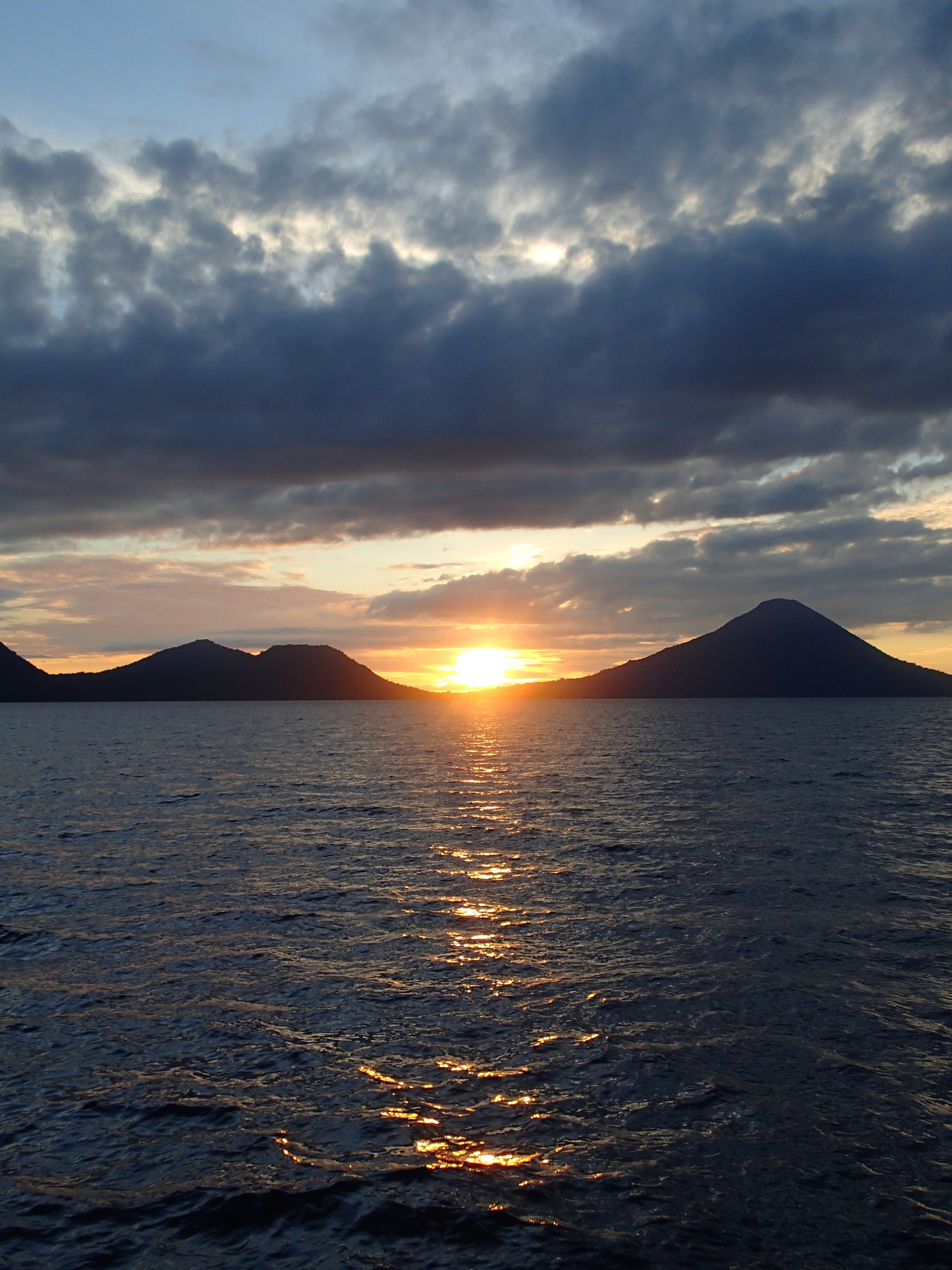
Beautiful Resolution bay where Captain Cook anchored in 1776.

The John Frum temple with American flags flying overlooking the John Frum village

The John Frum temple with American flags flying overlooking the John Frum village

John Frum Prophesy mural depicting door on the Yasur volcano through which John Frum will return.

John Frum Prophesy mural depicting door on the Yasur volcano through which John Frum will return.

Inside the John Frum temple with village elders.

Inside the John Frum temple with village elders.

Chief Isaac and Bryan in front of John Frum Prophesy mural.

Chief Isaac and Bryan in front of John Frum Prophesy mural.

Our traditional bungalow on the black volcanic sand beach of SE Tanna Island.

Our traditional bungalow on the black volcanic sand beach of SE Tanna Island.

Traditional cooking - fire started without matches, no metal pots, pans or implements - steamed foods via heated stone/pit cooking methods.

Traditional cooking – fire started without matches, no metal pots, pans or implements – steamed foods via heated stone/pit cooking methods.

Posted in Uncategorized | 2 Comments

VANUATU

ON TO VANUATU

We’re now in the South Pacific nation of Vanuatu, known before their independence from France and Britain in 1980 as the New Hebrides. Vanuatu is a chain of more than eighty islands stretching north to south five hundred miles, located east of Australia and south of the Solomon Islands. To reach Vanuatu, we headed about two hours west from Fiji (in the direction of Australia), landed in the capital city of Port Vila on the island of Efate, then headed north to the largest island, Espiritu Santo (“Santo”). You may not have heard of Santo, but you probably have heard of it. Santo inspired Michener (who was based there during the Pacific War, and to which he returned to after) to write his famous “Tales of the South Pacific”, which, in turn inspired Rogers and Hammerstein to write the hit musical “South Pacific”. Very much Melenesian (see previous post), most of Vanuatu is still a land of traditional culture, with arguably some of the most beautiful beaches and coral reefs in the world. Like our previous stops, we came to Vanuatu to experience the culture, SCUBA dive and generally explore.

The Coolidge And Million Dollar Point – “Military Intelligence” Strikes Again

During the dark days of 1941/early 1942, during the opening months of the Pacific War, things were going rather badly for the Allies. Pearl Harbor was famously attacked, Hong Kong and the Philippines were seized, the British stronghold of Singapore fell and the northern town of Darwin in Australia was being bombed almost daily. America was looking for a forward base from which to begin their assault on the Empire of Japan in the South Pacific. The huge natural harbor at the southern tip of Santo was eventually selected and within six months more than 45,000 American servicemen were stationed there, with more than a quarter of a million coming and going through it, and back through it again (including my uncle) to and from the fighting further north in the Solomons and New Guinea. Second only to Pearl Harbor, Santo was the largest forward American base during the Pacific War.

The Coolidge Disaster

Before The War, the President Coolidge was the floating definition of traveling in style across the Pacific. Built in 1931 at the Newport News Shipyard in Virginia, the Coolidge called San Francisco home port and sailed to and from Yokohama, Hong Kong, Shanghai, Sydney, Honolulu and other destinations. General MacArthur met his wife while on the Coolidge, bound for Manila (also on the Coolidge was, at the time, a rather un-famous Major named Dwight D. Eisenhower). With war threatening, the Coolidge was commandeered by the U.S. military and converted to a troop transport. Most of her luxurious fixtures were either removed or boarded up, but not all (see below), and her staterooms and salons were fitted with bunks six high to accommodate 5,000 troops plus another 10,000 tons of cargo. Thus configured and loaded, the Coolidge set out for the new forward base at Santo, unescorted, zig zagging to avoid Japanese submarines eight thousand miles across the Pacific. Weeks later the lights of the Santo base were sighted. Having received no further instructions, and fearing the Japanese subs, Captain Nelson promptly proceeded into the Segund Channel fronting the base, assuming a pilot ship would be dispatched for docking instructions. All was fine and good except for one minor detail the Navy failed to inform good Captain Nelson of: The channel had been mined! Minutes later the signalman on the bridge received a message flashed from shore: REVERSE. MINE FIELD. Too late. An enormous explosion rocked the ship as eighteen hundred pounds of T.N.T in an anti-shipping mine blew a hole big enough for a truck in the side of the Coolidge. Then another went off under the stern. Knowing his ship was lost, Captain Nelson ordered full speed ahead and hard starboard, running the Coolidge aground onto the reef fronting the beach about a mile from the Santo Base. Amazingly, all five thousand troops, save one brave Captain checking on his men in the bowels of the ship, got off and waded ashore covered in oil and without any of their gear but happy to be alive. About an hour later, the stern of the Coolidge began to settle. Within hours, the Queen Of The Paific slipped back into the Segund Channel where she rests today, her bow in about fifty feet, her stern in about two hundred and forty. Down with the Coolidge went everything one could imagine needed for thousands of troops headed for battle: rifles, ammunition, artillery, trucks, aircraft, tanks, food, clothing. Most critical was the entire Pacific supply of quinine, then the only effective treatment for malaria, thus dooming the Marines on Guadalcanal to thousands of cases of that deadly disease in the months to come. The loss of the Coolidge, both the supplies therein and her use as a transport, set the Pacific War back months and arguably cost thousands of extra lives. SNAFU (I’ll let you look that one up if you don’t know) on steroids.

Diving The Coolidge

What was then an epic example of “military intelligence” and great disaster has now become one of the greatest wreck dives of the world. Just slightly smaller than the Titanic, the Coolidge now lies on her port side just off the beach near what is now the small town of Luganville, which sprung up from the huge Santo Base after the war (many of the base Quonset huts are still in use). Though penetrating a wreck is usually reserved for highly technical divers, the Coolidge is unique due to its enormous size, relative ease of access and it being well-explored. An advanced diver with good buoyancy control can explore some of the interior spaces, provided he/she is with an experienced Coolidge divemaster (we were). Having said that, the Coolidge pushes the depth limits of non-technical diving and an accidental fin flip in the interior can raise a fog of rust particles, reducing visibility to zero. A good dive flashlight, with a reserve, and a calm non-claustrophobic disposition are required (it was still pretty darned spooky, however).

Our underwater guide to the Coolidge was a local Ni Vanuatu named Etienne. Etienne had made over a thousand dives on the Coolidge and would lead us on a fascinating trip through the passageways of the ship, just as it was when it sunk some seventy years ago. On our first dive, we rolled over the side of a small boat and followed a buoy that led down to the bow of the ship. As we sank thru the water column, the enormity of the Coolidge came into view – I felt like a very small ant exploring a rather large picnic basket. The port 3-inch bow gun, installed during the troop transport conversion, loomed into view, now pointed for eternity at the sand below. As we swam down the deck, helmets and rifles lay everywhere: troops reported to their muster station to abandon ship with them, only to be told to ditch their gear before they made the hundred foot climb over the side and down to the water. Etienne aped for my camera, donning one of the helmets and pointing a rifle in an underwater combat pose (see picture below). We then dropped through an enormous cargo door on the side of the ship (now angled towards the surface) and made our way down a long passageway, now in complete darkness, save shafts of light streaming through the upturned portholes. Below us, our flashlights illuminated enormous heaps of materiel caused by the list of the ship and the collapse of bulkheads over the years brought on by the regular earthquakes Santo experiences and corrosion. Howitzer artillery shells lay strewn here and there like giant matchsticks. At the end of the passageway lay an iconic vision of the Coolidge wreck – “The Lady And The Unicorn” – a ceramic bas relief that once adorned the first class smoking room, its colors still vibrant (see pictures). I briefly studied my gauges, noting that the “Lady” was at nearly one hundred forty feet, the recreational diving limit, constraining our time with her to just a few minutes. After my shooting of a few images, we reversed out of the “Lady” room and back through passageway, slipping between bulkhead struts to swim through another cargo bay before emerging through yet another cargo area. Our limited “bottom time” – the amount of time you can spend a given depth due to nitrogen saturation (see previous post), was getting short. As we moved back into the shallower waters at the bow, I noticed the enormous anchor chain streaming over the side, each link the size of a small watermelon. After a surface interval, we made another dive on the Coolidge, this time entering through a cargo hold. A few underwater twists and turns brought us into the barbershop with its recognizable chair, now appearing to be crazily bolted to the wall. A medicine cabinet in the adjoining sick-bay still had rows of potions neatly stored in shelves. Pictures below.

“Military Intelligence” Part Two: “Million Dollar Point”

As the War marched north through the Solomon Islands and New Guinea, the huge base at Santo became more and more distant from the action and new, more forward, albeit smaller bases took its place. But that didn’t stop the military from continuing to ship huge quantities of materiel to Santo. By the end of the War, acres of supplies, armaments, ammunition, food, clothing, fuel, aircraft, tanks, jeeps, trucks and millions of other things were still stored at Santo. So, what to do with all this stuff? Politicians didn’t want to flood home markets with it when companies were in the process of getting their civilian footings back. The French wouldn’t agree on a price, the Australians didn’t have the shipping to move it, and the local Ni Vanuatu (persons from Vanuatu) were not even consulted. Above all, everyone wanted to go home. The last thing they wanted to do is to stay at Santo inventorying all this vast horde of materiel, and otherwise dealing with it. So, what did they do? A lot of the small stuff they simply abandoned in the Quonset hut warehouse farms along the Segund Channel. All the big stuff – trucks, jeeps, tanks, cranes….were bulldozed into the sea (and then they drove the bulldozers in on top of them). All of it brand new or nearly so. This appalling waste (yet another application of “military intelligence”), has now created one of the most unique dives in the world, a place since dubbed “Million Dollar Point”. We jumped in just off the beach and looked onto a bizarre spectacle: huge trucks, flipped upside down with jeeps piled on top in a heap that had to be sixty feet tall. Tanks, capsized turret-down, were strewn in between. Enormous piles of helmets and helmet liners, looking, like some weird turtle mating frenzy, littered the sand floor (and the beach). Interestingly, an enterprising local, using a floating crane he raised, pulled up a Caterpillar tractor shortly after the war, drained the engine, changed the oil and electricals and fired it up. He then used it to pull out another twenty or so. Now that would make an interesting Cat commercial… What a titanic waste….

Next, onto to the island of Tanna in Vanuatu

The President Coolidge, on the reef on Santo, August 1942

The President Coolidge, on the reef on Santo, August 1942

Coconut crab...it's what's for dinner!

Coconut crab…it’s what’s for dinner!

Amazing array of tropical fruits and vegetables at Luganville Market, Santo, Vanuatu

Amazing array of tropical fruits and vegetables at Luganville Market, Santo, Vanuatu

The amazing but appalling waste at Million Dollar Poine

The amazing but appalling waste at Million Dollar Poine

The "Lady and The Unicorn" Deep within the wreck of the Coolidge

The “Lady and The Unicorn” Deep within the wreck of the Coolidge

The massive hulk of the Coolidge Wreck

The massive hulk of the Coolidge Wreck

Sick-bay medicine cabinet in the Coolidge.

Sick-bay medicine cabinet in the Coolidge.


Etienne dons a helmet and rifle from the deck of the Coolidge

Etienne dons a helmet and rifle from the deck of the Coolidge

Posted in Uncategorized | 1 Comment

BULA! FROM FIJI

ON TO FIJI

We’ve now moved south to Fiji – hundreds of islands sprinkled over thousands of square miles of the blue, blue South Pacific and about seventeen degrees below the equator – due east of Cairns on the east coast of Australia and out about a twelve hundred miles. Fiji is a cultural/ethnic crossroads of the three great Central/South Pacific cultures: Polynesian (which most are familiar with – Hawaii, French Polynesia, New Zealand), Micronesia (small islands scattered across the Central Pacific including the Palau chain, Yap, Chuk (Truck), Pohnpei, others), and Melanesia (New Guinea, the Solomon Islands, Vanuatu, others). Of the three, Fiji is most aligned ethnically with Melanesia, but cultural influences come from all three, as well as the British who began contact/colonization some two hundred years ago.

After a brief stop at Nadi (pronounced “nandi” – in Fijian, the letter “d” usually has a silent “n” in front of it) on the biggest island of Viti Leviu, we flew down to Kadavu (again the silent “n”) for several days of diving the Great Astrolabe Reef – one of the largest barrier reefs in the world, birding (about eight species live nowhere else), and exploring the unique culture there.

Flying in a Twin Otter

For our trip down to Kadavu, we, along with one other passenger had a Fiji Airways Twin Otter to ourselves. For those who have traveled to remote places, the De Haviland Twin Otter aircraft is usually an old friend. Twin engined, simple to maintain, rugged and unpressurized, the Twin Otter can take off from strips most would think impossible. On these short bush airstrips, Otter passengers cannot help but notice a unique ritual. The pilot taxies to the end of the strip, pivots the plane facing down-strip and into the wind, locks the landing gear, then takes the engines up to full power. The engine roar and shuddering airframe is awesome. The co-pilot then places his hand on top of the pilot’s hand on the red knobbed throttles (one for each engine), hand over hand, to be absolutely sure they don’t slip back from full during take off. When the pilot releases the brakes, the Otter shoots down the strip like if was fired from a catapult and into the air faster than you would believe possible. Bush “E Ticket” ride!

Kadavu

On Kadavu, we stayed at Matava, one hour’s trip via open launch and into the teeth of the Trade Winds inside the Astrolabe Reef lagoon, slaloming between the patch reefs through azure waters. Matava is run by a fascinating Brit ex-pat, who has created a beautiful and peaceful place off the grid on the south shore of Kadavu. When we arrived, what is normally spectacular diving outside the Astrolabe Reef wasn’t possible due to the southeasterly trade winds turbocharged by a high pressure system over the ITCZ (Inter-Tropical Convergence Zone, a.k.a “the doldrums”) to the north. The subsequent high seas made it impossible to get safely through the barrier reef pass and into the crystalline oceanic waters. I was reminded of the great early 60’s surfing movie “The Endless Summer”, where the running theme was: “you guys really missed it, ya shoulda been here last week…” (the previous week, the seas were flat calm with water visability at 200’). Ironically, the surfing appeared to be amazing, with miles of perfect overhead curls and tubes breaking on the Great Astrolabe Reef. Not a single surfer rode them.

Even with marginal weather, our stay on Kadavu was great. We learned much about Fijian culture, walked that beautiful island and decompressed – literally and figuratively – from our previous 10 days of diving in New Guinea

On to the Na’ia, The Bligh Waters and the Northern Islands

On returning to the big island of Viti Livu, we boarded the Na’ia, another “liveaboard” dive boat (see previous post), where we again spent ten days of diving ane exploring what Jacques Cousteau called “the soft coral capital of the world”. During the ten days, we headed north up the west coast of Viti Levu, then south and east through the Bligh Waters (as in the infamous captain of the Bounty who navigated his open boat through these waters when cast adrift two hundred years ago), and down the east coast of Viti Levu to some of the more remote island chains. Cousteau was right about the soft coral. Soft coral, like their stony cousins, consist of large colonies of polyps – individual animals related to sea anemones, but with a plant or bush-like appearance when seen as a whole. Commonly called sea fans or gorgonians, and being filter feeders, soft corals, open their feathery arms with stronger currents in the most spectacular colors imaginable. Blue, pink, purple, fluorescent red…and many colors in between. One way to experience them is to do a “drift dive”, meaning that you jump into a strong current, normally caused by tides rushing into and out of coral lagoon “passes” (breaks in the reef system), and drift along underwater, watching the show. And what a show it is. Soft corals unfold like a spectacular underwater wildflower display, and as you pivot and look out into the blue (most drift dives are along a wall that may drop from just a few to hundreds or thousands of feet), reef sharks and other big predatory fish soar on the aquatic wind, very much like a hawk does in air, inspecting the vast schools of reef fish for those vulnerable to their swift attack (sharks are normally not a threat to divers – indeed they are the highlight of many dives).

“Yachties” Nomads Of The Sea

Upon disembarking from the Nai’a we stayed for a few days at a mellow place away from the main tourist haunts around Nadi. The place (First Landing – named after the place the first Fijians landed fifteen hundred years ago according to legend) was next to a small craft harbor full of small sailing vessels from every corner of the globe. Transom lettering spoke of ships from Australia, New Zealand, California, France, South Africa, Holland, and more. A few things immediately identify a sailboat rigged to spend serious time in blue water. Most have something called a “vane” on their transom (back of the boat), which looks, and indeed acts, much like a weather vane does in air. You set the vane to sail you at a given point to the wind and it then takes over the helm, making corrections by its wind vane. In areas of consistent winds like the trades, the wind blows consistently from the same direction for thousands of miles (NE in the northern hemisphere, SE in the south). A vane liberates you from the helm, sometimes for days or weeks on end. Most blue water sailboats also do not have “Marina Del Rey”style gleaming hardware and china white decks. The topside is typically arrayed with solar panels, emergency liferafts, heavy duty anchor tackle, spare rigging, fuel and water jugs – the things you need for days or weeks or months at sea. At this marina near Lautoka, “Yachties”, as those who have adopted the nomadic lifestyle of living on their boats are known, are busy with a thousand tasks. Many have had their boat hauled and are repairing the hull and cleaning/repainting the bottom, servicing the prop and its cutlass bearing. Others are treating weathered wood decks, replacing worn shrouds, backstays and mast spreaders, debugging electronic and communications gear and much more. A couple – he from Maine, she from Panama – came on board the Nai’a for dinner one night. He set our five (or was it six…) years ago from Maine, sailed down the east coast of the U.S. through the Caribbean, stopping in Panama to rebuild his bank account by building tourist bungalows, got married, then transited the Canal and set out across the Pacific to New Zealand, through the Solomons, Tonga and now Fiji. Their boat, 34’, was all business – beautiful in the functional way the great blue Pacific demands.

Our next stop is the island chain and nation of Vanuatu…more from there.

Cheers,
Bryan

A massive manta ray soars past the reef wall

A massive manta ray soars past the reef wall

Jane with soft coral

Jane with soft coral

Endemic Fijian clownfish in fluorescent sea anemone.

Endemic Fijian clownfish in fluorescent sea anemone.

Grey reef shark glides by

Grey reef shark glides by

The Kadavu/Astrolabe reef logoon

The Kadavu/Astrolabe reef logoon

Fijian reefs from the air.

Fijian reefs from the air.

Fellow divers and crew of the Nai'a

Fellow divers and crew of the Nai’a

Villige visit and Kava ceremony

Villige visit and Kava ceremony

The Nai'a

The Nai’a

Posted in Uncategorized | 2 Comments

LEAVING NEW BRITAIN, DIVING THE BISMARCK SEA

ANICDOTES AND OBSERVATIONS FROM NEW BRITAIN

Before we leave New Britain here are two short stories….local stories…remembered from the Pacific War.

“UNCLE AMERICA”

In the immediate wake of Cyclone Ita, we arrived in Alotau and took a boat to a diving lodge beyond the roads of Milne Bay at the extreme southeast point of Papua New Guinea. On our boat was Edward, a man from the PNG island of New Britain, the largest island in the Bismarck Archipelago (and our next stop). We spoke on the boat and over the next few days on all manner of subjects as he sorted out the IT/internet issues at the lodge in the wake of the cyclone. Edward had lived and studied in Pittsburgh, enduring a Pennsylvania winter (and his first experience of snow). He had fond memories of the warm people (in spite of their climate), though virtually no one had more than the vaguest clue as to what/where PNG was, let alone New Britain, and where baffled as to why he looked like an African American (to them)…..didn’t all people from the South Pacific look like Hawaiians?

Edward also recounted to me a rather touching story from the Pacific War. In late 1943, America landed 10,000 Marines of the First Division at Cape Glouster – the western point of New Britain- to wrest a series of airbases from the Japanese. As they fought their way east, the Marines encountered Edward’s village, where his grandmother was in the midst of a difficult childbirth. Several Marine medics noticed a commotion in the village and asked their local guides what the commotion was about. They lent a hand and Edward’s uncle was born. His grandmother, grateful for the help the medics, felt she must name her new son after one of the Marines. But which one? After considering the situation, and consulting with the elders, Edward’s uncle was rather democratically named “America”. America still lives in the province of West New Britain of Papua New Guinea. Edward visits him whenever he can.

THE SPITFIRE UNDERCARRAGE IS IN OUR BEDROOM

The rugged, roadless rainforest mountains of New Britain hide hundreds of aircraft wrecks from the Pacific War, many of which have yet to be discovered. New Britain also hosts a small but close knit ex-pat community. I met some of them at the annual ANZAC Day remberance (Australian, New Zealand Army Corps. – the equivalent to America’s Memorial Day, focused on the ANZAC sacrifices during World War I, II) in the small town of Kimbe in West New Britain where we happened to be during the annual memorial gathering. Over the years, a small subset of these PNG ex-pats have taken up the challenge of finding at least some of these wrecks, both through their own explorations and contact with the remote clans and tribes in the New Britain interior. In many cases, these discoveries have closed sixty year old MIA cases through a fascinating process of identifying not only the air craft type, but the one individual aircraft from the mangled remains one can imagine would be left after plummeting though the rainforest canopy. Amazingly, many of these IDs were made by something as simple as an engine part, radio gear, wing guns, and in some cases, the personal effects and/or bone fragments of the air crew. We were lucky enough to befriend one of these amazing ex-pats (the name will remain unnoted as it is technically illegal to hunt for these wrecks per PNG law). Pending a proper museum that is anticipated some day, their home was an astonishing collection of WW II aircraft bit and pieces – aircraft engines, wing guns, ammunition, controls, radio gear, reconnaissance cameras, even a roll of the enormous film negatives used in them. Our friend recounted years of searching based mostly on the tips from older locals who remembered the aircraft going down. In some cases they reunited pilots or their surviving relatives with their aircraft. And yes, they did have a Spitfire fighter landing strut in their bedroom!

ON TO THE BISMARCK SEA AND DIVING

After our experiences on New Britain, we boarded the 72’ MV Febrina, a “liveaboard” dive boat, for 10 days of diving the remote pinnacles, reefs and islands of the Bismarck Sea. What’s it like being on a liveaboard dive boat? Close quarters for sure. And it’s all along the diving (but you typically also establish great friendships in the process). A typical day involves arising before six for a quick cup of coffee and re-check of your SCUBA and camera gear, then in the water on the first dive by 6:30. After anywhere from 30 to 90 minutes underwater (sixty on average for us), a surface interval of about an hour is had to eat breakfast and to rid the body tissues of dissolved “residual” nitrogen (you don’t want to be a like a beer bottle when it opens and suddenly “decompresses”, filling with bubbles). The next dive is typically at 9:30, followed by a dive at 11:30, 3:30 and a night dive on many days, for up to five dives a day. Save for our Aussie captain (a 30 year PNG hand that was both politically incorrect and hilarious), the crew were all from PNG (most from New Britain). The divemasters (underwater safety officers and guides) – a man and a woman – were both excellent, looking out for both our safety and guiding us to cool stuff you’d never find on your own, like the pygmy seahorse (see below).

THE CORAL TRIANGLE

Over the millennia, coral reef systems have waxed and waned with climatic heating and cooling periods, contracting and expanding with their need for warm, clear water. But part of the Pacific deemed “the coral triangle” (generally New Guinea, the Solomon Islands, Parts of Malaysia, Indonesia and the Phillipines) have weathered these climatic swings for millions of years. The result is an almost incomprehensible level of diversity. Case in point: Hawaii, where many have either snorkeled or dived, hosts about fifty species of coral. New Guinea has more than five hundred (and counting). Many are familiar with the beautiful reef fish known as angelfish. The Caribbean hosts about six species. New Guinea? More than a hundred and fifty. To dive on the reef systems of New Guinea (there are still thousands of square miles of healthy reefs here), is a mind boggling kaleidoscope of color, diversity and near infinite complexity. The coral triangle is a 3D rainforest on steroids.

Here’s one personal story from the Coral Triangle….

The fantastic creature known as the pygmy seahorse (there are several species, all from the Coral Triangle) mimics the sea fans it lives on so perfectly that, in combination with its quarter inch size, is virtually impossible to find without spending hundreds of hours underwater at the sites we dove, which our divemasters had. They’d pass twenty sea fans, then carefully inspect a few square inches of another and….voila…pygmy sea horse (see pictue). To say photographing a pygmy sea horse is challenging, is like saying Jacques Cousteau kinda liked the ocean. In addition to dealing with all the normal diving stuff: buoyancy control, air and decompression status, location of dive buddy etc. you are dealing with a macro lens stopped down up to F40 (that means the lens opening is pinhole sized), with a quarter inch of movement in or out determining whether your miniature equine of the sea is in focus or not. On top of this, the little critters are usually determined to turn away from you. This is where your divemaster can help you out (that is, help ME out) – locating and relocating my diminutive subject while I bang away with fifteen pounds of housed Nikon SLR camera, high powered strobes, and related gear – adjusting F stops, strobe power, strobe/camera position, holding your exact position in the water column and hoping one ofthe shots will be in focus with your subject facing the camera (I had limited success). Underwater photography (Jane does video, I do still) is equal parts technology, skill, persistence and masochism.

So what was the takeaway from spending the equivalent of two full working weeks underwater (forty dives averaging an hour each) in the Bismarck Sea, heart of the Coral Triangle? In these days of rainforest/coral reef gloom and doom, there are still places like Papua New Guinea where, after surfacing from a dive, you can pivot your head down thirty degrees and see absolutely pristine coral reefs – mound coral, brain coral, branched coral, lettuce coral – and fish of every size, shape and color in massive abundance, then pivot your head up to gaze upon mountain range after mountain range of uncut rainforest. Yes, there are still places like that out there!

Pygmy Sea Horse On Sea Fan. Size: 1/4"

Pygmy Sea Horse On Sea Fan. Size: 1/4″

Sunset Over Wittu Islands , Bismarck Sea

Sunset Over Wittu Islands , Bismarck Sea

MV Febrina on the Bismarck Sea

MV Febrina on the Bismarck Sea

Glassy day on the Bismarck Sea. Water Temp 86.

Glassy day on the Bismarck Sea. Water Temp 86.

Posted in Uncategorized | 2 Comments

ON TO NEW BRITAN AND THE BISMARCK SEA

THE BISMARCK ARCIPELAGO: RABAUL, EAST NEW BRITAN

We’ve now left the “mainland” of Papua New Guinea (PNG) and are on the three hundred mile long island of New Britain, the largest of the Bismarck Archipelago. New Britain is hundreds of square miles of mountainous rainforest, punctuated by great conical, steaming volcanoes and hot tub temperature rivers. We’re at the eastern tip of New Brittan at Rabaul, an area of intense history – both human and geological – during the twentieth century.

The mountainous spine and brooding volcanoes of New Britain were born of the subduction zone between the Australian plate and the Pacific plate – part of the Indo-Pacific “Ring Of Fire”. Around Rabaul alone are seven active volcanoes, the most being Vulcan and Tavurvur, both of which erupted with great force in 1994, burying Rabaul in six to nine feet of ash, essentially turning that historic town into the modern day equivalent of Pompeii, but not erasing the enormous footprint of “Fortress Rabaul”, the base of some 300,000 Japanese sailors and soldiers built by the Empire Of Japan during World War II.

In the history of the Pacific War, Rabaul looms large. After their back-to-back victories at Pearl Harbor, Singapore, Malaya, the Philippines and other parts of the Southwestern Pacific in late 1941/early 1942, the Japanese siezed from the Australians (who, in turn, seized from the Germans after WWI) the near perfectly protected deep water harbor and town of Rabaul. Rabaul was Japan’s Pearl Harbor in every sense. Indeed, most of the first two years of the American involvement in The Pacific War was focused on isolating Rabaul and its satellite bases at Kavieng on New Ireland and Bouganville (in the Northern Solomon’s). The infamous fighting on the (Solomons) island of Guadalcanal was all about wresting that satellite airstrip from the Japanese they had built there in order to commence the terribly bloody island-stepping campaign north towards Rabaul (“Operation Cartwheel”). It cost approximately 100,000 American lives to isolate Rabaul along with dozens of aircraft carriers, battleships, heavy cruisers and other capital ships lost to both sides (for an excellent overview, download “The Lost Fleet Of Guadalcanal” done on the fiftieth anniversary of the fighting in which all sides came together again, and famed Titanic finder Bob Ballard discovered a number of the shipwrecks). Today much still remains of the hundreds of miles of tunnels, the five airbases, and the huge infrastructure built by the Japanese during The War, both above and below water. One of the military sites we visited around Rabaul was the “Submarine Base” where the Japanese (or rather their slave labor) dug a tunnel complex at a unique cliff site where the water is nearly a thousand feet deep right up to the shore. During the intense 24/7 bombing (the Allies dropped something like 20,000 tons of bombs on Rabaul), the Japanese were reduced to attempted resupply by submarine, with this unique site permitting subs to stop offloading and immediately submerge directly from the jetty built for that purpose. Above the Base lived a man named George who was forced to help dig many of the Sub Base tunnels as a young man. I asked what happened if he was sick, needed to tend his garden for his own food or otherwise did not work on a given day: “they find you, then chop your head off in front of the others”…. Beyond the numerous gun emplacements and wrecked aircraft (both above and below the water – see images below including Japanese Zero fighter just offshore), another amazing site was a system of huge tunnels containing three enormous landing barges, sill at the ready to launch in an attempt to resupply the beleaguered Japanese troops on Guadalcanal (see image). Our next stop will further west on New Britan where we, along with six other others will board the eighty foot long MV Febrina at Kimbe for diving and exploring the remote offshore islands, seamounts and reefs of the Bismarck Sea.

Intact Japanese Zero fighter in 100' of water, ditched by the pilot upon return to "Fortress Rabaul".

Intact Japanese Zero fighter in 100′ of water, ditched by the pilot upon return to “Fortress Rabaul”.

Ruins of the town of Rabaul, buried under six to nine feet of volcanic ash after the 1994 eruption (Vulcan volcano steaming in background)

Ruins of the town of Rabaul, buried under six to nine feet of volcanic ash after the 1994 eruption (Vulcan volcano steaming in background)

Wreck of Japanese Betty Bomber at end of one of the five airstrips built around Rabaul by the Japanese During WWII.

Wreck of Japanese Betty Bomber at end of one of the five airstrips built around Rabaul by the Japanese During WWII.

Wreck of the Atun Maru, one of more than fifty large Japanese ship sunk by Allied bombing and now at the bottom of Simpson Harbor, Rabaul

Wreck of the Atun Maru, one of more than fifty large Japanese ship sunk by Allied bombing and now at the bottom of Simpson Harbor, Rabaul

Posted in Uncategorized | 1 Comment

Papua New Guinea

Greetings from Enga Provence in the Western Highlands of Papua New Guinea.

We’re sitting this afternoon at over eight thousand feet in front of a warm fire as the chilly afternoon rains set in. I’m reading (the recently passed) Peter Matheson’s classic “Under The Mountain Wall” about the Dani People (50 years ago) and Stone Age culture in Papua New Guinea. Currently we’re in the Enga province of the Central Highlands staying at the Kumul Lodge (constructed of traditional materials and built by the Enga people), having spent the morning (successfully) seeking out and viewing two species of the absolutely astonishing Birds Of Paradise (see more, and photos below).

We’ve now been in Papua New Guinea (PNG) for a little over a week, having initially skirted Cyclone Ita (category 4) that brushed Alotau, our first stop, located in the Milne Provence at the extreme southeastern tip of PNG. At Alotau, we spent several days SCUBA diving on pristine coral reef systems after spending a half-day exploring the sites and artifacts of the fierce fighting in August 1942, where several thousand Australian/American forces handed an equal number of landing troops of the Imperial Japanese Army their first land defeat of World War II. Though seventy years ago, the War was still very much remembered in Alotau and in the villages around Milne Bay, and they gladly shared their remembrances, and the fascinating albeit rarely reported local point of view from a culture with one foot still in the stone age at that time.

AIRPLANES, OTHER ASTONISHMENTS AND THE WAR

Seventy years ago, few Papuans had ever seen an airplane, let alone conceive of the concept. While waiting for a transfer flight at the Alotau airport and with several hours to kill, I struck up a conversation with an older local man and I asked him about the War. He described the experience of his father as a young boy and others while out fishing from their outriggers in front of their village one day on Milne Bay in August 1942. Suddenly, a fighter plane came roaring up over the ridge south of them and dropped down to wave hopping level, most likely an American built P-40 on its way to strafe the landing Japanese Troops, the fighter flying from the Australian air strip miles distant (which is now the Alotau airport where we were both sitting). Everyone paddled back to the village as fast as they could, only to find all members turned out on the beach. The elders quickly convened a discussion as to what they had just seen, and the consensus was it was some kind of very fast, huge, noisy bird. Male villagers were to carry their spears, bows and arrows in case it returned to attack the village. Later, communication with villages up the coast on the matter indicated that white men (Dim-Dim) were seen emerging from the giant birds when they landed, which explained where the white men (which they had already encountered) came from – the giant bird had clearly given birth to them. They were the children of the giant, fast noisy birds! Later, they learned the Dim-Dim had built the giant birds, they called “aiplen”, but that just opened up a Pandora’s Box of questions, wonders and bafflements as the war raged through New Guinea (paramount was “Why the hell are you guys here?”). As an epilogue, just a few years ago, a man hunting in the forested mountains behind Alotau, discovered a P-40 fighter in and below a giant rainforest tree. The remains of the pilot, to that point a MIA, was determined, solving a 65-year-old mystery and providing closure for an Australian family. A pair

of fifty caliber wing guns from the wreck sits below that hunter’s house (see pictures). As one can imagine the War was a life changing experience for the Papuans and other Melanesian cultures of the South Pacific, so much so that it spawned a new religion – The Cargo Cult, that still is practiced today (more on that in another blog).

ON PAPUAN CULTURE AND THE ORIGIANAL ORGANIC GARDENERS

In the 30’s a pair of Australian gold prospectors named the Leahy Brothers were the first whites to penetrate the (eighteen thousand foot high) Central Ranges of PNG. It was assumed that the Central Ranges were devoid of human population. Much to their astonishment, they discovered a huge valley (one of many) at over eight thousand feet populated by thousands of persons living a stone age, agricultural existence (download the documentary “First Contact” shot by the Leahy Brothers with their 8mm camera). This meeting astonished both cultures: the Papuans by these cadaverous looking people…or the incarnation of their ancestors…..or whatever they were….and the Leahys (and their entourage) by the massive and most unexpected audience they had created. The epilogue of this First Contact was that the Leahys never found much gold but discovered these high valleys were perfect for growing coffee…brown gold… and the Papuans established contact with the outside world. This cultural encounter happened near the Central Highlands town of Mt. Hagen, about an hour from where we are now. Less noticed and/or publicized at the time was the fact that the Papuans had been gardening successfully in the same valleys for thousands of years without depleting the land. It goes without saying they used no chemical fertilizers or pesticides, but they also used sophisticated composting, crop rotation and drainage techniques…all many attribute to the “organic farming revolution” of the 60’s and 70’s…sorry guys, you’re about 5,000 years late: the Papuans had been conducting organic gardening”since most Euro/Mediterranean cultures were emerging from hunter/gather lifestyles. And they still do. Most Papuans (including our guests) still grow nearly all their own food, using these same practices on the lands they have lived on for millennia (stone tool artifacts have dated the populating of PNG back at least 50,000 years).

THE PAPUANS…..

With over 800 distinct languages spoken, New Guinea is the most linguistically diverse place on earth. For fifty thousand years,hundreds of cultures have lived in isolation from each other in high mountain valleys, remote islands and lowland floodplains separated by vast wetlands. Most now communicate with each other with a creole of English: Tok Pisin.

So what are our rural Papuan hosts like ?(photos an video clips to follow). As with all diverse peoples, hard to generalize, but there are many cross cultural traits we’ve encountered: kind,curious (most have still have had limited contact with people of European ancestry), soft spoken, and very much a tightly knit social society. As long as you are invited, announce yourself, or escorted by a member of their clan they respect, you are invariably greeted with a smile and a handshake.

ON ORGANIC GARDENING….

One fascinating thing about our (highland) guests is their straddling of the modern and traditional worlds. Few wear shoes, and most still grow their own food. They still live in traditional thatched homes with walls and floors of woven split/pounded bamboo-like materials. Yet most also own cell phones and use them not only to keep in touch with relatives but also to establish the best time to harvest and/or sell cash crops, such as coffee, small plots of which many grow. Their life is still ruled by their traditional and ancient clan relationships. If you’re a young man and want to get married, you’ll still have to meet a bride price from the clan in question, usually payable in pigs (Papuans traditionally have only two domestic animals: pigs and dogs, with pigs serving more as a store of wealth/currency than a food source). Another aspect of Papuan culture, much studied since health writer Nathan Pritikin made note of their near complete lack of heart disease (amongst those still living traditional lifestyles) and obiesity, due to a naturally low fat, vegetable based diet, and naturally high in fiber and nutrients. Though infant mortality is high, it is not uncommon for rural Papuans to live to, and beyond, one hundred years, like the 95 year old woman we met walking down the road in Alotau who well remembered cooking for the Australian soldiers 75 years ago as the fighting raged back and forth through her village (see her portrait, below).

Coming in next blog: On to the Bismarck Archipelago – Rabaul, Kimbe and the Bismarck Sea.


The pristine coral reefs of Milne Bay

The pristine coral reefs of Milne Bay

Kids playing in post Cyclone Ita floodwaters - Alotau, Milne Provence, PNG

Kids playing in post Cyclone Ita floodwaters – Alotau, Milne Provence, PNG

Jane with 95 year old woman who remembered the WWII fighting 70 years ago.

Jane with 95 year old woman who remembered the WWII fighting 70 years ago.

50 cal wing guns from recently discovered Curtis P-40 fighter

50 cal wing guns from recently discovered Curtis P-40 fighter

WWII landing craft at Alotau

WWII landing craft at Alotau

Friend with lorikeet on shoulder

Friend with lorikeet on shoulder

The fantastic Ribbon Tailed Estrapia, one of the Birds Of Paradise, with it's three foot long tail and glowing blue/green plumage.

The fantastic Ribbon Tailed Estrapia, one of the Birds Of Paradise, with it’s three foot long tail and glowing blue/green plumage.

Posted in Uncategorized | 3 Comments